Within Crash Photos
Do the Landmarks Match the Claimed Crash Site?
Roads, ridgelines, poles, drainage channels and buildings can test whether a photograph was really taken at the claimed recovery site.
On this page
- Which fixed features are most useful for location matching
- How maps and later photographs can confirm a viewpoint
- Why shadows and vegetation should remain supporting clues
Page outline Jump by section
Introduction
When an alleged UFO crash photograph is claimed to show a specific recovery site, the most valuable evidence is often not the supposed wreckage but the surrounding landscape. Roads, ridgelines, utility poles, drainage channels, buildings and other permanent features can frequently determine whether the image could have been taken at the claimed location. Unlike captions, witness recollections or digital metadata—which may be incomplete, altered or disputed—fixed landmarks can often be compared independently with maps, satellite imagery, historical aerial photographs and ground-level views.
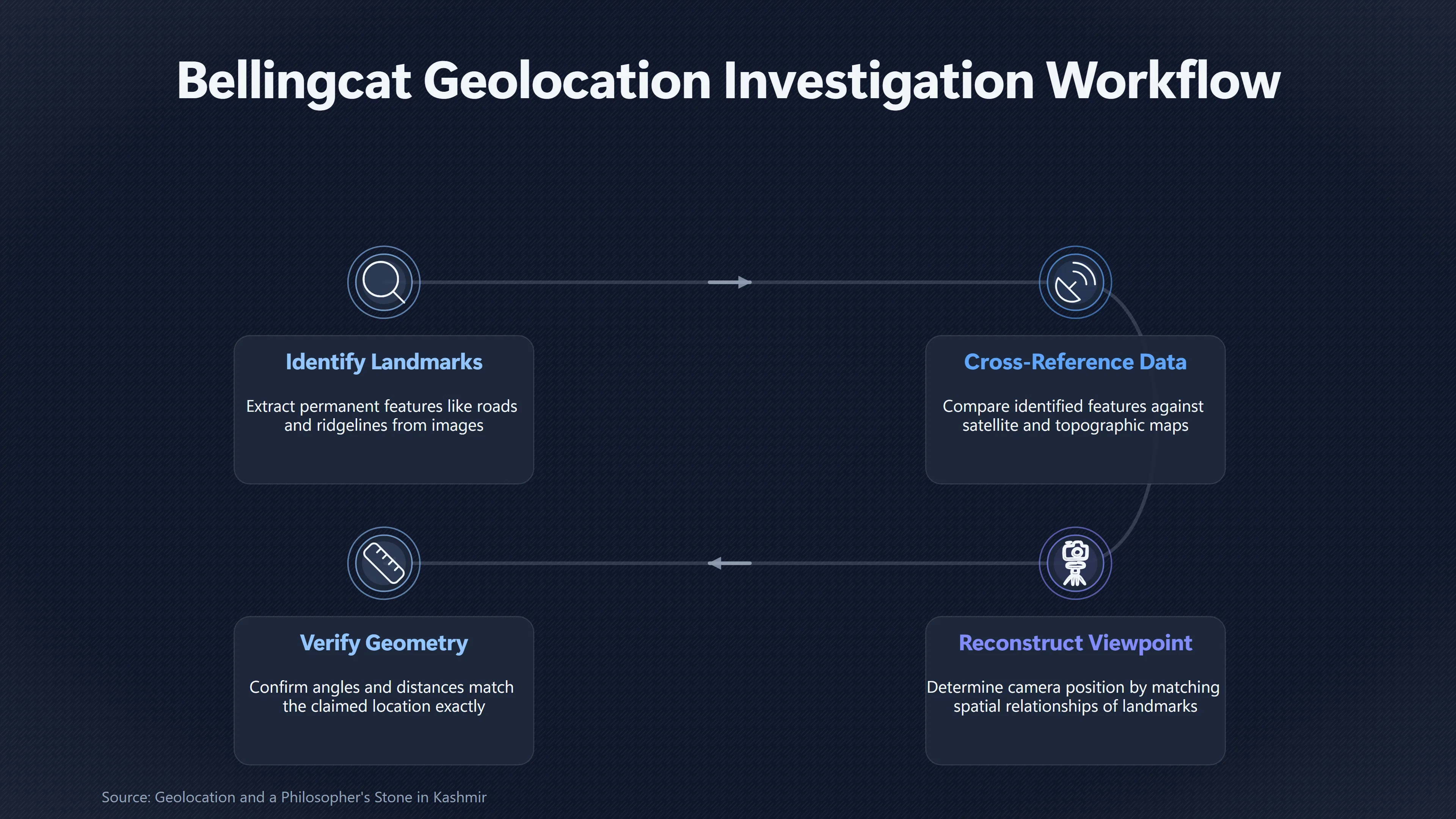
For this reason, geolocation has become a standard part of open-source investigations as well as forensic image analysis. Rather than asking whether an object in a photograph looks unusual, investigators first ask a simpler question: do the visible surroundings match the place where the image is claimed to have been taken? If they do not, the broader crash claim becomes much weaker regardless of what the object appears to be.[bellingcat]bellingcat.comGeolocation and a Philosopher's Stone in KashmirGeolocation and a Philosopher's Stone in Kashmir - bellingcatMarch 4, 2019…
Which Fixed Features Are Most Useful for Location Matching?
The strongest location clues are features that remain stable over many years. Temporary objects such as vehicles, tents or people contribute little because they can easily be moved. Instead, investigators concentrate on elements whose position is effectively permanent.
Particularly valuable landmarks include:
- Road alignments and junctions – bends, intersections, lane markings, road widths and embankments frequently provide distinctive geometry.
- Ridgelines and mountain profiles – the outline of hills or peaks is often unique when viewed from a particular direction.
- Drainage channels and streams – culverts, dry washes, gullies and river bends usually change slowly over time.
- Utility poles and transmission lines – spacing, alignment and the number of crossarms often provide measurable reference points.
- Buildings and farm structures – roof shapes, wall orientation and relative positions help establish camera viewpoint.
- Fence lines and field boundaries – these frequently appear in both aerial imagery and ground photographs.
- Large rocks or isolated trees – although vegetation changes over time, mature trees and distinctive boulders can remain recognisable for decades.
No single feature is normally sufficient. Instead, investigators look for combinations that fit simultaneously. A road may resemble many others, but a road that bends beside a drainage ditch, passes a particular hill profile and aligns with a specific utility line becomes far more distinctive.[bellingcat]bellingcat.comStunt GeolocationStunt Geolocation - Verifying the Unverifiable - bellingcat…
How Maps and Later Photographs Can Confirm a Viewpoint
Once several landmarks have been identified, investigators attempt to reconstruct the camera position rather than merely finding a similar-looking place.
This usually involves comparing the photograph against multiple independent sources:
- satellite imagery;
- historical aerial photography;
- topographic maps;
- publicly available street-level imagery where available;
- later photographs taken from suspected viewpoints.
The goal is not simply to find similar terrain but to determine whether the spatial relationships between visible features match.
For example, if a claimed crash photograph shows a road crossing a drainage channel with a ridge appearing immediately behind a building, all three relationships should remain consistent when viewed from the reconstructed camera position. If moving the virtual camera causes the ridge to separate from the building or the drainage line to disappear, the proposed location becomes less convincing.
Modern open-source investigations commonly use terrain visualisation alongside satellite imagery because elevation strongly affects what is visible from any viewpoint. Even remote locations with few buildings can often be matched through the arrangement of hills, valleys and prominent rock formations. A published investigation into the geolocation of photographs from the 2019 Kashmir MiG-21 crash demonstrated this process by combining terrain analysis with distinctive boulders, vegetation patterns and local place names until a precise viewpoint was identified.[bellingcat]bellingcat.comGeolocation and a Philosopher's Stone in KashmirGeolocation and a Philosopher's Stone in Kashmir - bellingcatMarch 4, 2019…

Matching the Entire Scene Instead of One Landmark
A common mistake is to stop after finding one feature that appears similar. Robust geolocation requires that the entire visible landscape agree with the claimed location.
Investigators therefore compare:
- relative distances between landmarks;
- angles between roads and ridgelines;
- apparent elevation changes;
- perspective created by the camera;
- visibility or obstruction of background features.
Perspective is especially important. A telephoto lens compresses distance, making hills appear closer to foreground objects, while a wide-angle lens exaggerates spacing. Consequently, a convincing match depends on reproducing the overall geometry rather than relying on isolated similarities.
This explains why photographs taken from later site visits can be extremely valuable. If a modern image captured from the reconstructed viewpoint reproduces the same alignment of roads, hills, buildings and poles, confidence in the location increases substantially. Conversely, persistent mismatches suggest the original claim may be incorrect or that the published photograph came from another place altogether.[bellingcat]bellingcat.comStunt GeolocationStunt Geolocation - Verifying the Unverifiable - bellingcat…
Why Shadows and Vegetation Should Remain Supporting Clues
Shadows and vegetation can help narrow possible locations, but they are generally weaker evidence than fixed landmarks.
Shadow direction may indicate whether a claimed camera orientation is plausible if the photograph’s date and approximate time are known. Modern analytical tools can estimate the sun’s position and compare measured shadows against possible locations. However, this approach depends on accurate timing, vertical reference objects and relatively flat ground. Even then, shadow analysis normally narrows possibilities rather than proving a unique location.[bellingcat]bellingcat.comChasing Shadows: Geolocate Images with Bellingcat's Shadow Finder ToolChasing Shadows: Geolocate Images with Bellingcat's Shadow Finder Tool - bellingcatAugust 22, 2024…
Vegetation presents similar limitations. Forest edges, hedgerows and mature trees can assist location matching, but growth, logging, wildfire, agriculture and seasonal variation all change the landscape. Grass colour, crop height or leaf cover may support other evidence but rarely identify a site on their own.
For these reasons, experienced investigators treat both shadows and vegetation as corroborating evidence. They become persuasive only when they reinforce stronger geographic matches established through terrain, roads, drainage systems and permanent structures.[bellingcat]bellingcat.comChasing Shadows: Geolocate Images with Bellingcat's Shadow Finder ToolChasing Shadows: Geolocate Images with Bellingcat's Shadow Finder Tool - bellingcatAugust 22, 2024…
Common Sources of False Matches
Several factors can create convincing but incorrect geolocation claims if not carefully considered.
Generic landscapes. Desert plains, forests and grasslands often contain repeated patterns that appear interchangeable over large areas.
Lens distortion. Wide-angle cameras alter apparent distances and angles, making direct comparison with satellite imagery unreliable unless perspective is accounted for.
Landscape changes. Roads may be widened, buildings demolished, utility poles replaced or river courses modified between the date of the photograph and later comparison imagery.
Selective framing. A tightly cropped image may exclude nearby landmarks that would quickly confirm or contradict the claimed location.
Confirmation bias. Once investigators become convinced that a particular site is correct, they may unconsciously overlook features that do not fit. Reliable geolocation instead seeks potential contradictions alongside supporting evidence. A single unexplained inconsistency does not necessarily invalidate a match, but multiple independent discrepancies usually deserve greater weight than one or two visual similarities.[bellingcat]bellingcat.comGeolocation and a Philosopher's Stone in KashmirGeolocation and a Philosopher's Stone in Kashmir - bellingcatMarch 4, 2019…

What Landmark Analysis Can—and Cannot—Establish
Matching landmarks can answer an important but limited question: whether a photograph was probably taken at the claimed location.
It cannot, by itself, establish what caused debris to appear there or whether photographed material is extraordinary. A successful geolocation merely demonstrates that the image is consistent with the stated site. Questions about the nature, origin or interpretation of any alleged wreckage require separate lines of evidence.
Within investigations of alleged UFO crashes, this distinction is crucial. Establishing that a photograph genuinely depicts the claimed recovery area is a prerequisite for evaluating stronger claims about what was photographed. Equally, demonstrating that the surrounding landmarks do not match the alleged site may be enough to reject the photograph as reliable evidence, regardless of how unusual the central object appears.
Amazon book picks
Further Reading
Books and field guides related to Do the Landmarks Match the Claimed Crash Site?. Use these as the next step if you want deeper reading beyond the article.
Open Source Intelligence Techniques: Resources for Searching...
Completely Rewritten Sixth Edition Sheds New Light on Open Source Intelligence Collection and Analysis Author Michael Bazzell has been we...
Maphead: Charting the Wide, Weird World of Geography Wonks
Record-setting Jeopardy! champion-turned-host and New York Times bestselling author of Planet Funny Ken Jennings explores the world of ma...
The Data Journalism Handbook
"A project of the European Journalism Centre and the Open Knowledge Foundation."--T.p. verso.
eBay marketplace picks
Marketplace Samples
Live-tested eBay searches with available results related to this page.
Selected fromUFO wall art oneBay.co.uk.
Endnotes
1.
Source: bellingcat.com
Title: Geolocation and a Philosopher’s Stone in Kashmir
Link:https://www.bellingcat.com/resources/case-studies/2019/03/04/geolocation-and-a-philosophers-stone-in-kashmir/
Source snippet
Geolocation and a Philosopher's Stone in Kashmir - bellingcatMarch 4, 2019...
Published: March 4, 2019
2.
Source: bellingcat.com
Title: Stunt Geolocation
Link:https://www.bellingcat.com/resources/case-studies/2015/03/03/stunt-geolocation-verifying-the-unverifiable/
Source snippet
Stunt Geolocation - Verifying the Unverifiable - bellingcat...
3.
Source: bellingcat.com
Title: More than Mountaineering: Using Peak Visor for Geolocation
Link:https://www.bellingcat.com/resources/2023/07/13/more-than-mountaineering-using-peakvisor-for-geolocation/
Source snippet
More than Mountaineering: Using PeakVisor for Geolocation - bellingcat...
4.
Source: bellingcat.com
Title: Chasing Shadows: Geolocate Images with Bellingcat’s Shadow Finder Tool
Link:https://www.bellingcat.com/resources/2024/08/22/shadow-geolocate-geolocation-locate-image-tool-open-source-bellingcat-measure/?trk=public_post_comment-text
Source snippet
Chasing Shadows: Geolocate Images with Bellingcat's Shadow Finder Tool - bellingcatAugust 22, 2024...
Published: August 22, 2024
5.
Source: bellingcat.com
Link:https://www.bellingcat.com/news/uk-and-europe/2015/10/08/mh17-the-open-source-evidence/
6.
Source: youtube.com
Title: Finding a Location from an Image | Geolocation, OSINT Challenge | Episode No. 6
Link:https://www.youtube.com/watch?v=p7_2ZA1HHMo
Source snippet
Bellingcat Geolocation Tutorial How to Geolocate Photos Start Your Geolocation Search With Ease Bellingcat...
7.
Source: bellingcat.gitbook.io
Link:https://bellingcat.gitbook.io/toolkit/more/all-tools/peakvisor
8.
Source: bellingcat.gitbook.io
Link:https://bellingcat.gitbook.io/toolkit/more/all-tools/shadow-finder
Additional References
9.
Source: ta-training.it
Title: OSIN T Geolocation: The Bellingcat Method Step by Step — TA Training Program
Link:https://ta-training.it/classified/geolocalizzazione-osint-bellingcat-metodo
Source snippet
OSINT Geolocation: The Bellingcat Method Step by Step — TA Training ProgramApril 26, 2026 — OSINT GEOLOCATION: THE BELLINGCAT METHOD STEP...
Published: April 26, 2026
10.
Source: geospy.tech
Title: No caption, no metadata, no
Link:https://geospy.tech/en/blog/osint-image-geolocation-guide
Source snippet
A Complete Guide to Finding Where Photos Were Taken | GeoSpyJuly 9, 2026 — A COMPLETE GUIDE TO FINDING WHERE PHOTOS WERE TAKEN Editorial...
Published: July 9, 2026
11.
Source: osintguide.com
Title: The workflow has four p
Link:https://www.osintguide.com/en/blog/osint-for-investigative-journalism
Source snippet
OSINT for Investigative Journalism · OSINT GuideDecember 26, 2022 — A VERIFICATION WORKFLOW FOR USER-GENERATED CONTENT When a dramatic im...
Published: December 26, 2022
12.
Source: youtube.com
Title: 10 Minute Tip: How to geolocate from images and videos, Part 1
Link:https://www.youtube.com/watch?v=X7E6zinrkno
Source snippet
Finding a Location from an Image | Geolocation, OSINT Challenge | Episode No. 6...
13.
Source: youtube.com
Title: OSINT At Home #4 – Identify a location from a photo or video (geolocation)
Link:https://www.youtube.com/watch?v=RoqWbpZUOSo
Source snippet
10 Minute Tip: How to geolocate from images and videos, Part 1...
14.
Source: youtube.com
Title: OSINT At Home #13 – Using mountains to geolocate a photo or video
Link:https://www.youtube.com/watch?v=vNu2X7aCMkU
Source snippet
OSINT At Home #4 – Identify a location from a photo or video (geolocation)...
15.
Source: stateofsurveillance.org
Link:https://stateofsurveillance.org/articles/technical/geolocation-osint-photo-location-tracking/
16.
Source: youtube.com
Title: Start Your Geolocation Search With Ease
Link:https://www.youtube.com/watch?v=FiiRpaayqag
Source snippet
OSINT At Home #13 – Using mountains to geolocate a photo or video...
17.
Source: osintdirectory.com
Title: OSIN T Playbooks
Link:https://www.osintdirectory.com/playbooks/geolocation