Within Field Protocol
Can the Debris Pattern Survive Evidence Collection?
Measured positions, orientations and search limits can distinguish an impact pattern from later disturbance or uncertain witness recovery.
On this page
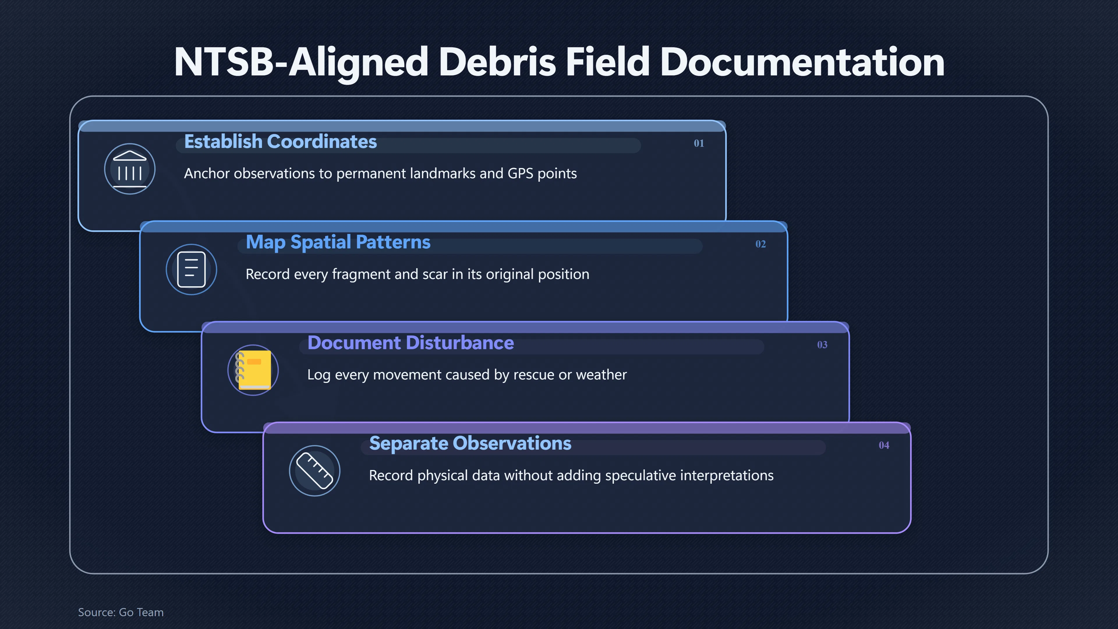
- Establishing fixed coordinates and landmarks
- Plotting fragments, scars and field boundaries
- Marking uncertain finds and unsearched areas
Page outline Jump by section
Introduction
If investigators receive a fresh report of a suspected UFO crash, the most valuable evidence may not be an unusual fragment but the original spatial pattern in which every object, ground mark and damaged feature was found. Before anything is moved, that pattern can preserve clues about direction of travel, breakup sequence, secondary impacts and whether later disturbance has altered the scene. Once recovery begins, those relationships may be impossible to reconstruct with confidence.
For that reason, a debris field should be documented as an unknown impact scene rather than interpreted as evidence of an extraordinary craft. Aviation accident investigators, forensic scene specialists and scientific guidance on unidentified anomalous phenomena all emphasise careful measurement, accurate recording and preservation of context before conclusions are drawn.[NTSB]ntsb.govAVIATION INVESTIGATION MANUAL - MAJOR TMarch 17, 2026…
Why the first map matters more than the first recovery
A debris field is not simply a collection of objects. It is a record of physical events frozen in space.
The position of the largest object may attract immediate attention, yet the smallest fragments, vegetation damage, scrape marks and isolated impact points often reveal how an object travelled and broke apart. Investigators therefore seek to document the entire affected area before concentrating on individual pieces. This approach mirrors established aviation investigation practice, where the distribution of wreckage is used alongside structural analysis and ground evidence to reconstruct an accident sequence.[NTSB]ntsb.govGo TeamNTSB Go Team…
In the context of a reported UFO crash, the same principle applies without assuming what the object is. A mapped field can later support multiple competing explanations—including aircraft debris, space hardware, weather equipment, deliberate hoaxes or genuinely unidentified material—because all hypotheses rely upon knowing where evidence originally lay.
Establishing fixed coordinates and landmarks
The first objective is to anchor every later observation to permanent reference points that will remain identifiable long after the scene changes.
Investigators normally establish a fixed coordinate system using surveyed reference points, GPS measurements where appropriate and easily recognisable permanent landmarks such as road junctions, buildings, utility poles or geological features. These references allow photographs, sketches, drone imagery and physical measurements to be integrated into one consistent spatial record.[NIST]nist.govOSAC 2023-N-0002 Standard for Scene Documentation Procedures | NIST…
Important implementation principles include:
- Defining a single reference origin for all measurements.
- Recording the coordinate system and measurement units used.
- Measuring from fixed landmarks rather than temporary markers.
- Photographing survey points before the scene changes.
- Recording measurement accuracy where equipment limitations exist.
This framework means later investigators can relocate positions even after vegetation has regrown, weather has altered the ground or recovered objects have been removed.
Plotting fragments, scars and field boundaries
Once reference points exist, documentation shifts from isolated discoveries to the pattern created by the entire field.
Every visible item should be recorded in place before collection, including:
- major wreckage or large fragments;
- small debris clusters;
- impact craters or depressions;
- scorch marks or burn patterns;
- disturbed soil;
- broken vegetation;
- scrape marks;
- apparent fluid stains;
- unusual surface impressions.
The relationship between these features often provides more information than any individual object.
For example, a long, narrow debris trail may suggest forward movement before final impact, while several separated fragment concentrations may indicate multiple breakup events or secondary collisions. Likewise, a concentration of lightweight material far downrange from heavier components may reflect aerodynamic separation rather than deliberate placement. Such interpretations are developed only after the original map has been preserved.[NTSB]ntsb.govGo TeamNTSB Go Team…
Field boundaries also deserve explicit documentation. Investigators should distinguish between:
- the confirmed debris field;
- the wider search area;
- regions examined but containing no finds; and
- areas that could not yet be searched because of terrain, hazards or access restrictions.
Negative observations can later become as important as positive discoveries.
Preserving orientation as well as position
Recording only where an object lies is often insufficient.
Large fragments may preserve their orientation relative to the direction of travel. A twisted panel, embedded object or elongated impact mark can indicate motion before coming to rest. Rotating or flipping an item before documenting it destroys that information permanently.
Where safe, investigators therefore record:
- compass orientation;
- angle of embedding;
- visible upper and lower surfaces;
- relationship to nearby marks;
- degree of penetration into soil or vegetation.
Ground scars should likewise be measured before foot traffic or recovery equipment obscures them.
Marking uncertain finds and unsearched areas
Not every reported object belongs to the incident.
A debris field may already contain unrelated rubbish, older metallic fragments or naturally occurring material. Rather than forcing immediate classification, investigators can distinguish between:
- confirmed scene items;
- probable associated material;
- uncertain objects requiring later examination; and
- unrelated background material.
This prevents later confusion between evidence and coincidental finds.
Similarly, search limits should be documented honestly. Dense woodland, standing water, unstable ground or hazardous materials may prevent complete examination during the initial response. Recording exactly which areas remain unsearched helps later teams avoid assuming the entire scene was examined equally thoroughly.
Combining sketches, photographs and aerial mapping
No single recording method captures every spatial relationship.
Ground sketches remain valuable because they emphasise measured distances and object relationships that may not be obvious in photographs. Photographs preserve appearance but often distort scale or hide elevation differences. Modern investigations increasingly supplement both with drone imagery and photogrammetric techniques that generate orthomosaic maps and three-dimensional scene models.[NTSB Data]data.ntsb.govData UAS Imagery ReportNTSB DataUAS Imagery ReportJuly 11, 2019…
When combined correctly:
- sketches document measurements;
- photographs capture condition;
- aerial imagery shows overall distribution;
- GPS coordinates provide geographic precision; and
- three-dimensional models preserve terrain relationships.
Each method reinforces the others rather than replacing them.
Recording disturbance instead of hiding it
Few real-world scenes remain perfectly untouched.
Emergency rescue, firefighting, hazardous-material response or weather may require unavoidable movement before investigators complete mapping. Rather than attempting to reconstruct an idealised scene, good documentation records every known disturbance.
Useful records include:
- which object was moved;
- who authorised the movement;
- why it occurred;
- the original estimated position;
- the new position; and
- the time of relocation.
This allows later analysts to distinguish original evidence from operational necessity instead of mistakenly treating altered positions as authentic. NTSB field guidance specifically emphasises documenting any manipulation of wreckage during rescue and recovery activities before detailed investigation begins.[NTSB]ntsb.govAVIATION INVESTIGATION MANUAL - MAJOR TMarch 17, 2026…
Separating observation from interpretation
Mapping should remain descriptive rather than speculative.
A field note stating that a fragment lay 14 metres north-east of a crater, partly embedded at approximately 40 degrees, is an observation. A note identifying it as extraterrestrial technology is an interpretation unsupported by mapping alone.
Maintaining this distinction protects the investigation from confirmation bias. NASA’s independent study of unidentified anomalous phenomena highlighted the importance of calibrated measurements, preserved metadata and multiple independent observations rather than early conclusions drawn from incomplete evidence.[ntsb.gov]ntsb.govGo TeamNTSB Go Team…
Can the debris pattern survive evidence collection?
Yes—but only if documentation comes before recovery.
Once fragments are bagged, transported or cleaned, investigators lose the original geometry that connected them. A carefully surveyed debris map preserves that geometry permanently, allowing later analysts to revisit competing explanations without relying solely on memory or photographs.
Whether a reported UFO crash ultimately proves to involve conventional aircraft wreckage, space debris, an experimental vehicle, a hoax or an event that remains unexplained, the evidential value of the scene depends first on preserving its original spatial pattern. The debris map becomes the reference against which every later laboratory examination, witness statement and reconstruction is measured.
Amazon book picks
Further Reading
Books and field guides related to Can the Debris Pattern Survive Evidence Collection?. Use these as the next step if you want deeper reading beyond the article.
Practical Crime Scene Processing and Investigation
All too often, the weakest link in the chain of criminal justice is the crime scene investigation. Improper collection of evidence blocks...
Aircraft Accident Investigation
Beskrivelse af situationer omkring flyvehavarier samt gennemgang af forhold i f.m. undersøgelser og udfærdigelse af rapporter.
Techniques of Crime Scene Investigation
"Techniques of Crime Scene Investigation is a staple for any forensic science library and is routinely referenced by professional organiz...
Crime Scene Photography
Crime Scene Photography is a book wrought from years of experience, with material carefully selected for ease of use and effectiveness in...
eBay marketplace picks
Marketplace Samples
Live-tested eBay searches with available results related to this page.
Selected fromUFO wall art oneBay.co.uk.




Endnotes
1.
Source: ntsb.gov
Link:https://www.ntsb.gov/about/Documents/MajorInvestigationsManualApp.pdf
Source snippet
AVIATION INVESTIGATION MANUAL - MAJOR TMarch 17, 2026...
Published: March 17, 2026
2.
Source: ntsb.gov
Title: Go Team
Link:https://www.ntsb.gov/investigations/process/Pages/goteam.aspx
Source snippet
NTSB Go Team...
3.
Source: nist.gov
Link:https://www.nist.gov/standard/976
Source snippet
OSAC 2023-N-0002 Standard for Scene Documentation Procedures | NIST...
4.
Source: ntsb.gov
Title: The Investigative Process
Link:https://www.ntsb.gov/investigations/process/Pages/default.aspx
Source snippet
The Investigative Process...
5.
Source: data.ntsb.gov
Title: Data UAS Imagery Report
Link:https://data.ntsb.gov/Docket/Document/docBLOB?FileExtension=.PDF&FileName=UAS+Imagery+Report-Master.PDF&ID=40474043
Source snippet
NTSB DataUAS Imagery ReportJuly 11, 2019...
Published: July 11, 2019
6.
Source: nist.gov
Title: Forensics Science — Crime Scene | NIST
Link:https://www.nist.gov/forensic-science/nist-forensics-science-crime-scene
Source snippet
May 27, 2026 — NIST FORENSICS SCIENCE — CRIME SCENE Crime scene investigation includes everything that happens to document, locate, prese...
Published: May 27, 2026
7.
Source: ntsb.gov
Title: Report an [Aircraft Accident]({{ ‘aircraft-accidents/’ | relative_url }}) to the NTSB
Link:https://www.ntsb.gov/Pages/aviationreport.aspx/1000
Source snippet
April 9, 2025 — REPORT AN AIRCRAFT ACCIDENT TO THE NTSB Page Content If you are an aircraft operator, Federal regulations req...
Published: April 9, 2025
8.
Source: ntsb.gov
Title: Media Resources
Link:https://www.ntsb.gov/news/Pages/media_resources.aspx
Source snippet
March 10, 2025 — MEDIA RESOURCES Page Content NTSB COMMUNICATIONS DURING MAJOR ACCIDENTS The NTSB is communicating investigative inf...
Published: March 10, 2025
9.
Source: ntsb.gov
Title: Aviation Investigation Classification
Link:https://www.ntsb.gov/about/organization/AS/Pages/aviation-classification.aspx
10.
Source: nist.gov
Title: process mapping
Link:https://www.nist.gov/forensic-science/process-mapping
Additional References
11.
Source: youtube.com
Link:https://www.youtube.com/watch?v=Y2YKYUIcGao
Source snippet
Episode 8- Everett Baxter Jr- Crime Scene Mapping with Drones...
12.
Source: youtube.com
Title: Episode 8- Everett Baxter Jr- Crime Scene Mapping with Drones
Link:https://www.youtube.com/watch?v=gGtSMMWiAsk
Source snippet
How are Drones Used in Crash and Crime Scene Reconstruction?...
13.
Source: ojp.gov
Link:https://www.ojp.gov/library/publications/crime-scene-investigation-guide-law-enforcement
14.
Source: ojp.gov
Link:https://www.ojp.gov/library/publications/crime-scene-investigation-guide-law-enforcement-0
15.
Source: faraim.org
Link:https://faraim.org/faa/far/cfr/title-49/part-831/section-831.13.html
16.
Source: youtube.com
Title: How are Drones Used in Crash and Crime Scene Reconstruction?
Link:https://www.youtube.com/watch?v=U1JW97P4OxM
Source snippet
Loc8 Online Quick Start Guide...
17.
Source: osha.gov
Title: Field Operations Manual
Link:https://www.osha.gov/fom/chapter-17
18.
Source: youtube.com
Title: Loc8 Online Quick Start Guide
Link:https://www.youtube.com/watch?v=0AAmQ0U_4eY
Source snippet
Video Analysis and Photogrammetry...
19.
Source: youtube.com
Title: Video Analysis and Photogrammetry
Link:https://www.youtube.com/watch?v=VomG3r6hn4w